Australia - Road Traffic Data
Explore an unparalleled dataset that brings to light the intricate patterns of road usage, congestion, and traffic flow across Australia. Empower your strategic decisions with data that captures the pulse of the nation's roads.


Vital Traffic Insights across the Australia
Delve into detailed metrics and analyses, uncovering the nuances of traffic flow, congestion hotspots, and speed trends essential for informed transportation planning and management across the Australia.
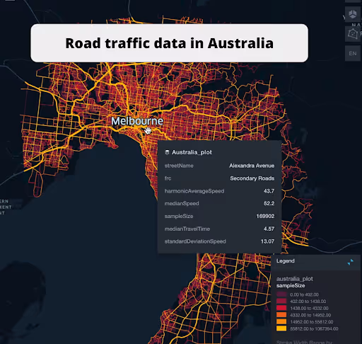
Snapshot of Australia Road Traffic
Preview the depth and breadth of our traffic data collection, showcasing how granular insights can revolutionize transportation planning and management in Australia.
Key Variables
Delve into detailed metrics and analyses, uncovering the nuances of traffic flow, congestion hotspots, and speed trends essential for informed transportation planning and management across the Australia.
Use Cases
How can this dataset benefit you?
Harness the power of comprehensive traffic data to design cities that breathe. Urban planners can create more efficient, less congested road networks that cater to the future of mobility.
Transform logistical challenges into opportunities by integrating real-time traffic data into routing algorithms. Reduce delivery times, improve fuel efficiency, and enhance customer satisfaction.
Leverage traffic insights to streamline emergency response strategies. Analyze patterns and identify the fastest routes to improve response times and potentially save lives in critical situations.
Median Speeds by Road Classes
This insight examines the average speed vehicles maintain across different road types, highlighting efficiency and congestion levels from highways to local streets.
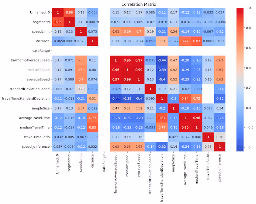
Co-relation Matrix

Offers a visual representation of how various traffic factors interrelate, such as speed limits, road types, and traffic volumes, revealing underlying patterns and dependencies.
Distribution of Speed Limits

Analyses the range and commonality of speed limits across Australia, indicating zones of high regulation and potential areas for speed limit adjustments.
Average Speed by Functional Road Class (FRC)

Breaks down average speeds according to the road's functional classification, providing insights into traffic flow and congestion on arterial roads versus local roads.
Average Speed Distribution by Nepean Highway

Focuses on speed patterns along this major highway, showcasing areas of congestion or high efficiency and their impact on travel times.
Average Speed by Street Name (Top 10 streets)

Lists the top 10 streets in terms of average speed, offering a snapshot of traffic conditions in busy urban areas or efficient thoroughfares.
Alexandra Avenue Street Road Traffic

Presents a detailed traffic flow analysis of Alexandra Avenue, including peak times, average speeds, and congestion points, using visual data.
City Link Tollway Street Road Traffic

Provides a graphical overview of traffic patterns on the City Link Tollway, highlighting efficiency, speed variations, and peak congestion times.
Why xMap?
xMap empowers businesses with unparalleled location intelligence and comprehensive data analysis, guiding them towards market leadership and growth.
Frequently Asked Questions
Find answers to commonly asked questions about our spatial analyst platform.
We update our data quarterly, ensuring you have access to the most current information.
It would be deal for traffic analysis, median speed, trend analysis and forecasting.
This dataset encompasses real-time and historical data on traffic density, accidents, road conditions, and congestion trends.

