United States of America | Road Traffic Data
A thorough and expansive dataset encapsulating the complexities of road traffic across the United States. This dataset is invaluable for transportation authorities, urban planners, and policy makers, offering critical data for infrastructure development, traffic management, and road safety initiatives.


Vital Traffic Insights across the U.S.
Delve into detailed metrics and analyses, uncovering the nuances of traffic flow, congestion hotspots, and speed trends essential for informed transportation planning and management across the United States.
Snapshot of U.S. Road Traffic
A segment of the dataset showcasing traffic patterns and trends across the United States, essential for strategic planning and analysis in transportation and urban development.
Key Variables
Delve into detailed metrics and analyses, uncovering the nuances of traffic flow, congestion hotspots, and speed trends essential for informed transportation planning and management across the United States.
Use Cases
How can this dataset benefit you?
Employ this dataset for developing and enhancing road networks, optimizing traffic flow, and reducing congestion in growing urban areas across the U.S.
Utilize the data for real-time traffic management, optimizing signal timings, and reducing congestion during peak hours in major cities.
Analyze traffic data to identify high-risk areas and implement targeted safety measures, reducing road accidents and improving overall safety.
New York Road Traffic Median Speed Data Visualization

Median Speed by Road Class
Example of Major Roads with Median Speed
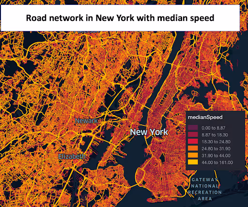
Road Network in New York with Median Speed

This insight provides an extensive analysis of New York's road network, showcasing the median speed on various streets and highways. It offers a clear perspective on traffic flow and velocity patterns, essential for urban planning and congestion management in the bustling city.
Road Speed Comparison in New York with Median Speed

A comparative analysis of road speeds across different areas in New York, this insight focuses on the median speeds to highlight variations and trends. It's crucial for identifying areas with high-speed traffic and potential safety risks.
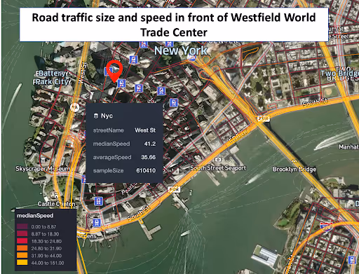
Road Traffic Size and Speed in Front of Westfield World Trade Center

Focusing on the area around Westfield World Trade Center, this data insight captures the volume and speed of traffic. It's instrumental for understanding the impact of this major commercial hub on local traffic conditions, aiding in traffic management and planning.
Why xMap?
xMap empowers businesses with unparalleled location intelligence and comprehensive data analysis, guiding them towards market leadership and growth.
Frequently Asked Questions
Find answers to commonly asked questions about our spatial analyst platform.
The dataset is updated after every 3 months to reflect any new entries, closures, and shifts in the grocery market dynamics.
It would be deal for traffic analysis, median speed, trend analysis and forecasting.
Yes, our dataset is compatible with major GIS platforms, allowing for seamless integration and analysis.

